


The Wales Way 2026: Route Map, Road Trip Planner & Complete Driving Guide
Written by the Wales.org Road Trip Team | Updated for 2026 | Routes Driven & Verified
The Wales Way is a family of three official national touring routes that together cover 440 miles of the most spectacular driving in Britain. Launched by Visit Wales, these interconnected road trips — The Cambrian Way, The Coastal Way, and The North Wales Way — are designed to showcase the very best of the Welsh landscape, from the highest mountain peaks to the wildest stretches of coastline, through ancient castle towns, hidden valleys, and communities where the Welsh language is still the first language of daily life.
🏴 The Wales Way at a Glance
- Total Combined Distance: Approximately 440 miles (710 km) across all three routes.
- The Three Routes: The Cambrian Way (185 miles), The Coastal Way (180 miles), The North Wales Way (75 miles).
- National Parks Crossed: Eryri (Snowdonia) and Bannau Brycheiniog (Brecon Beacons).
- UNESCO World Heritage Sites: 3 — Conwy Castle, Caernarfon Castle, and Beaumaris Castle (all on or near The North Wales Way).
- Recommended Time: 2–3 days per individual route. 7–10 days for all three combined as a circular road trip.
- Best Season: May to September for the longest daylight and best weather, though autumn (October) is stunning for colour.
- Fuel & Charging: Petrol stations are regularly spaced on the A-roads but can be 20+ miles apart on remote mountain passes. EV charging is improving but still limited in rural Mid Wales — plan carefully.
Unlike a rigid sat-nav route, The Wales Way is intended to be a framework rather than a fixed itinerary. The three routes can be driven individually as standalone road trips, combined into a single multi-week circuit of the entire country, or used as inspiration for shorter detours and side trips. The Welsh word for this approach is igam ogam — to meander, to wander — and it captures the spirit of these routes perfectly. The best experiences on The Wales Way are almost always the unplanned ones: the hidden waterfall you spot from a mountain pass, the farm shop you pull over for on a single-track road, or the medieval castle ruin you stumble upon in a valley you had never heard of.
This guide covers all three routes in detail, with the exact distances, key stopping points, postcodes, pricing, and practical driving advice you need to plan your 2026 Wales Way road trip from start to finish.
Interactive Wales Way Route Map
Explore the ultimate 440-mile driving circuit across Wales. We have color-coded all three official routes and pinned every must-see attraction, castle, and coastal viewpoint detailed in this guide. Click the menu icon in the top-left corner of the map to open the legend and toggle individual road trips and attractions on or off, or click any pin to see exactly where you are heading.
The Wales Way Route Map: 3 Routes Compared
Each route has its own distinct character. Choose one or combine all three into an epic circular road trip.
| Route | Distance | Start → End | Character | Min. Days | Best For |
|---|---|---|---|---|---|
| The Cambrian Way | 185 miles | Llandudno → Cardiff | Mountains & adventure | 3 days | Walkers, thrill-seekers, nature |
| The Coastal Way | 180 miles | Aberdaron → St Davids | Coast, beaches & wildlife | 3 days | Families, surfers, foodies |
| The North Wales Way | 75 miles | Queensferry → Holyhead | Castles, history & culture | 2 days | History buffs, castle lovers |
The Cambrian Way Route: 185 Miles Through the Spine of Wales
The Cambrian Way is the longest and most dramatic of the three routes, cutting directly through the mountainous backbone of Wales from the Victorian seaside resort of Llandudno (LL30) on the north coast to the capital city of Cardiff (CF10) in the south. The primary road is the A470, widely considered one of the most scenic trunk roads in Britain, and the route passes through two National Parks — Eryri (Snowdonia) and the Brecon Beacons (Bannau Brycheiniog) — with the remote, sparsely populated Cambrian Mountains in between.
This is the route for adventure lovers. The northern section takes you through the heart of Snowdonia, where Zip World, underground adventure centres, and world-class mountain biking trail centres are all within easy reach of the road. The central section crosses some of the emptiest uplands in Britain — vast, open moorland and glacial valleys where red kites soar overhead and you can drive for 20 minutes without seeing another vehicle. The southern section descends through the Brecon Beacons — one of only five International Dark Sky Reserves in the world — before entering the former coal-mining valleys and arriving in Cardiff.

Key Stops on The Cambrian Way (North to South)
Llandudno (LL30 2LP): The northern starting point — a beautifully preserved Victorian seaside resort with a sweeping promenade, pier, and the Great Orme headland accessible by cable car or tramway. Allow a half-day here before heading south. See our Llandudno guide.
Betws-y-Coed (LL24 0AH): The gateway village to Snowdonia, sitting at the confluence of three rivers in a densely forested valley. The Swallow Falls waterfall (£2 entry) is a 2-mile walk from the village centre. For accommodation here, see our Betws-y-Coed self-catering guide.
Blaenau Ffestiniog (LL41 3NB): A former slate quarrying town reinvented as Wales’ underground adventure capital. Zip World’s Go Below experience (from £69) takes you deep into Victorian caverns via zip lines, via ferrata, and underground boat rides. The narrow-gauge Ffestiniog Railway departs from here on one of the most scenic heritage rail journeys in Britain. See our adventure sports guide.
Dolgellau (LL40 1PS): A handsome stone market town at the foot of Cadair Idris (893m), the most dramatic mountain in southern Snowdonia. The Minffordd Path to the summit takes approximately 5 hours return and is one of the finest mountain walks in Wales. Coed y Brenin Forest Park (LL40 2HZ), just north of town, has world-class mountain bike trails.
Machynlleth (SY20 8EE): A characterful market town at the gateway to Mid Wales. Home to the Centre for Alternative Technology (SY20 9AZ, adults from £11) — a world-renowned eco-centre accessed by a water-powered cliff railway — and the Owain Glyndŵr Centre, marking the site where the last native Prince of Wales held his parliament in 1404.
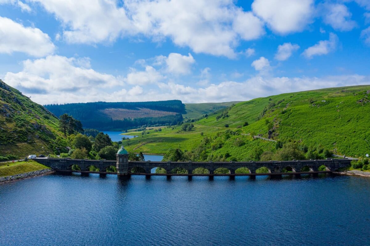
The Elan Valley (LD6 5HP): A short detour west from the A470 takes you to a chain of massive Victorian stone dams and reservoirs set in 72 square miles of protected moorland. The traffic-free Elan Valley Trail is a superb flat cycling route, and the valley is an internationally designated Dark Sky Park.
Brecon (LD3 7AD): The main town of the Brecon Beacons National Park. The starting point for walks up Pen y Fan (886m), the highest peak in southern Britain, and the spectacular Four Waterfalls Walk. See our Brecon Beacons guide.
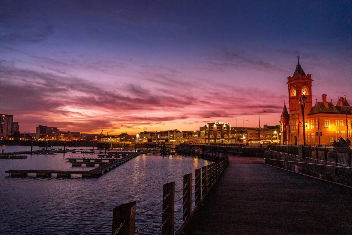
Cardiff (CF10 3RB): The Welsh capital and southern terminus. Cardiff Castle, the National Museum, the Victorian arcades, and Cardiff Bay are all within walking distance. Allow at least 1 to 2 full days. See our complete Cardiff guide.
The Wales Coastal Way Route: 180 Miles Along Cardigan Bay
The Coastal Way is a 180-mile road trip running the entire length of Cardigan Bay along the wild, west-facing Welsh coastline. It connects two ancient pilgrimage destinations — the tiny village of Aberdaron (LL53) on the tip of the Llŷn Peninsula to the smallest city in Britain, St Davids (SA62) — passing through an Area of Outstanding Natural Beauty, protected Heritage Coast, and some of the most unspoilt coastal scenery in Europe.
This is the route for those who want to get away from crowds. The Coastal Way runs through deeply rural, Welsh-speaking communities where the pace of life is slower and the coastline is dominated by hidden coves, empty beaches, working harbours, and a marine wildlife population that includes bottlenose dolphins, Atlantic grey seals, and one of Britain’s largest puffin colonies on Skomer Island off the Pembrokeshire coast.

Key Stops on The Coastal Way (North to South)
Aberdaron (LL53 8BE): The northern starting point on the very tip of the Llŷn Peninsula — a tiny, ancient pilgrimage village with a medieval church on the beach and spectacular views to Bardsey Island, the legendary resting place of 20,000 saints.
Criccieth (LL52 0HN): A picture-perfect seaside town dominated by a 13th-century castle perched on a headland between two beaches. Cadwalader’s ice cream is a compulsory stop.
Portmeirion (LL48 6ER): The famous Italianate fantasy village built by architect Clough Williams-Ellis between 1925 and 1975. Adult entry from £16. An extraordinary, completely unique attraction set in subtropical gardens on the shores of the Dwyryd estuary.
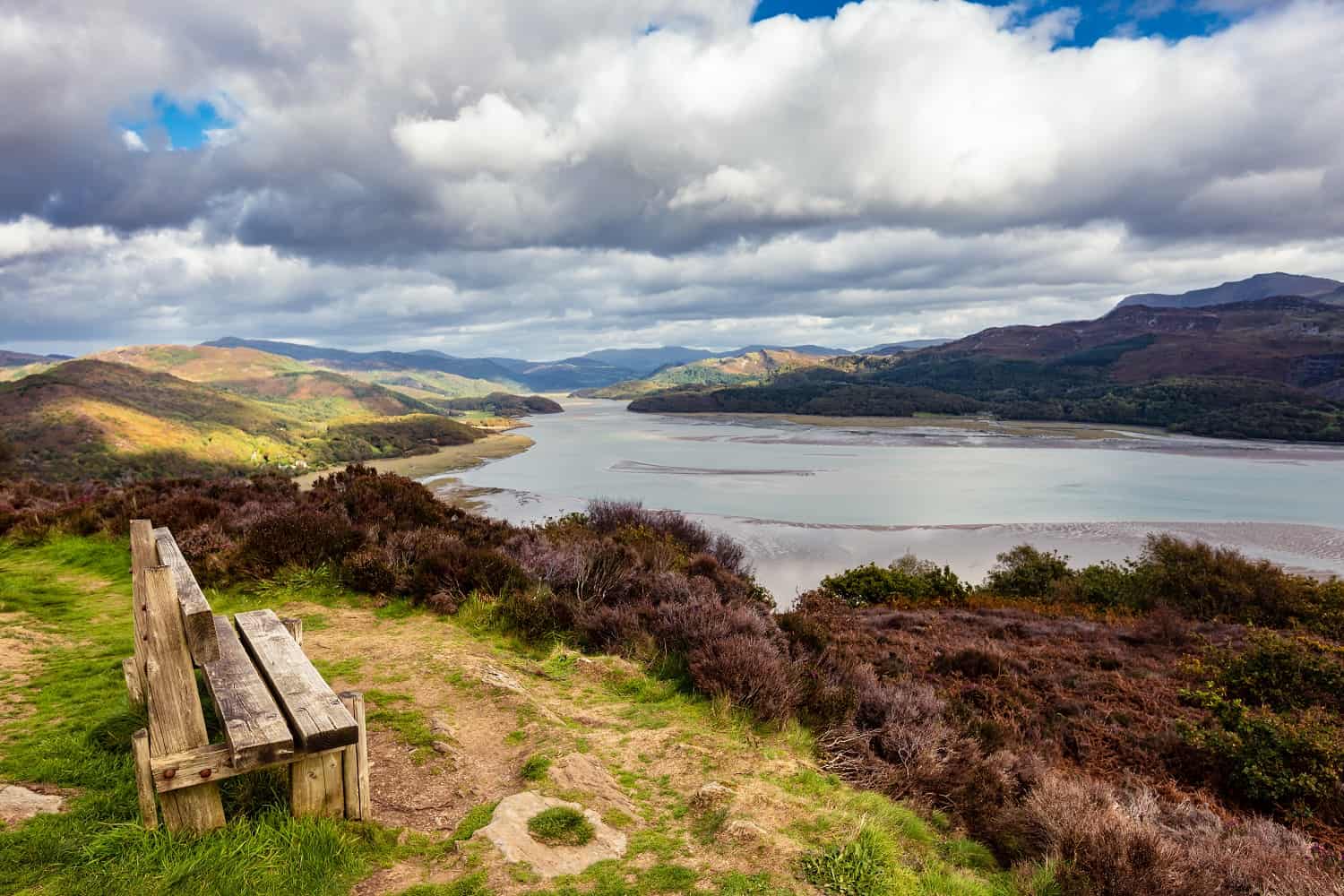
Barmouth (LL42 1LU): A Victorian resort town at the mouth of the Mawddach estuary. The railway bridge crossing the estuary is one of the most dramatic rail journeys in Wales. Excellent for sea kayaking and paddleboarding.
Aberystwyth (SY23 2AX): The vibrant university town and unofficial capital of Mid Wales. Constitution Hill (reached by the Victorian cliff railway, from £5 return) offers panoramic views over Cardigan Bay. The National Library of Wales (SY23 3BU, free entry) holds some of the most significant Welsh-language manuscripts in existence. See our Ceredigion & Cardigan Bay guide.
New Quay (SA45 9PS): The dolphin capital of Wales. Cardigan Bay is home to the UK’s largest resident population of bottlenose dolphins, and New Quay harbour is the best place to spot them from the shore. Boat trips run from the harbour from approximately £15 per person.
Cardigan (SA43 1JL): A historic market town at the mouth of the Teifi river. The restored Cardigan Castle is the birthplace of the Eisteddfod — Wales’ largest cultural festival. The Teifi estuary is superb for kayaking and wildlife watching.
St Davids (SA62 6RH): The smallest city in Britain and the southern terminus. The 12th-century cathedral — where Wales’ patron saint is said to be buried — is hidden in a dramatic valley below the village. This is the epicentre of Welsh coasteering, with operators running sessions along the cliffs from Whitesands Bay (from £45). See our Pembrokeshire guide.
The North Wales Way Route Map: 75 Miles of Castles, Coast and Culture
The North Wales Way is the shortest of the three routes at 75 miles, but it is arguably the most historically dense. Running along the northern coastline from Queensferry (near the English border) to Holyhead on the Isle of Anglesey, it follows the ancient trading route that connected England to the ferry port for Ireland. Along the way, it passes three UNESCO World Heritage castle sites — some of the finest medieval fortifications ever built — and a landscape that has been fought over, fortified, and settled for thousands of years.

Key Stops on The North Wales Way (East to West)
Flint Castle (CH6 5PE): The first of Edward I’s Iron Ring of castles, built in 1277. The ruins sit dramatically on the Dee estuary marshes. Free entry (Cadw managed). A powerful, atmospheric start to the route.
Conwy (LL32 8AY): One of the best-preserved medieval walled towns in Europe. Conwy Castle (UNESCO World Heritage, adult entry approximately £11.30) dominates the town. The town walls are fully walkable and offer superb views across the estuary and towards the mountains.
Llandudno (LL30 2LP): Where The North Wales Way connects with The Cambrian Way. The largest seaside resort in Wales, with a sweeping promenade, pier, and the Great Orme — a 207-metre limestone headland accessible by cable car, tramway, or on foot. See our Llandudno guide.
Caernarfon Castle (LL55 2AY): The most visually imposing of Edward I’s castles, and a UNESCO World Heritage Site. Built between 1283 and 1330 with distinctive polygonal towers and banded masonry, it was the site of the investiture of the Prince of Wales in 1969. Adult entry approximately £12.60. See our castles guide.
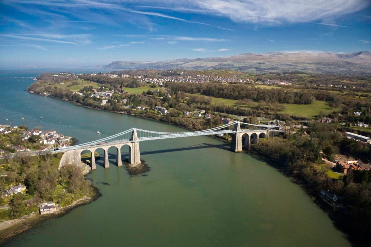
Menai Bridge and Anglesey: Thomas Telford’s Menai Suspension Bridge (1826) carries you across the Menai Strait onto the Isle of Anglesey. Beaumaris Castle (another UNESCO site, adult entry approximately £9.50) is among the finest examples of concentric castle design in Britain. The station sign at Llanfairpwllgwyngyll — the longest place name in Britain — is the island’s most famous photo opportunity.
Holyhead (LL65 1DQ): The western terminus and main ferry port for Ireland. South Stack Lighthouse (LL65 1YH), perched on a dramatic sea cliff just outside Holyhead, is one of the finest viewpoints in Wales and a major seabird colony with thousands of nesting guillemots, razorbills, and puffins from April to July.
🗺️ The Ultimate Wales Way Circuit: Combine All 3 Routes
You can link all three routes into a single circular road trip of approximately 440 miles. Here is our recommended 7 to 10-day clockwise itinerary:
- Days 1–2: Start in Cardiff. Drive The Cambrian Way north through the Brecon Beacons, Machynlleth, and Snowdonia to Llandudno (185 miles).
- Days 3–4: Pick up The North Wales Way. Head east to Conwy, then west along the coast through Caernarfon and across the Menai Strait to Anglesey (75 miles).
- Day 5: Head south from Anglesey onto the Llŷn Peninsula to Aberdaron — the northern start of The Coastal Way.
- Days 6–8: Follow The Coastal Way south through Cardigan Bay — Portmeirion, Barmouth, Aberystwyth, New Quay, Cardigan — to St Davids in Pembrokeshire (180 miles).
- Days 9–10: From St Davids, drive east through Carmarthenshire and back to Cardiff via the M4 to complete the circuit (approximately 150 miles).
When to Drive The Wales Way
May and June are the ideal months. The days are long (sunset after 9:00 PM in late June), the mountain passes are clear of winter weather, the wildflowers are at their peak along the coast path, and the summer holiday crowds have not yet arrived. Accommodation is significantly cheaper than July and August, and the puffins are nesting on Skomer Island along The Coastal Way.
July and August are the busiest months. The Coastal Way and North Wales Way can experience heavy traffic through popular towns like Conwy and Barmouth. Coastal accommodation books out months in advance. The Cambrian Way, by contrast, remains relatively quiet even in peak summer — the mountain roads see far fewer visitors than the coast.
![]()
September and October offer stunning autumn colour in Snowdonia and the Brecon Beacons, with quieter roads, lower prices, and excellent conditions for surfing on the Llŷn Peninsula as the Atlantic swells build. October is also peak grey seal pupping season along the Pembrokeshire cliffs — an incredible wildlife spectacle visible from The Coastal Way.
Winter (November to March) is dramatic but challenging. Mountain passes — particularly the A470 through Snowdonia and the A44 across the Cambrian Mountains — can be closed or treacherous in snow and ice. Daylight hours are short. However, winter driving along the North Wales coast and the lower sections of The Coastal Way is perfectly manageable. The Brecon Beacons Dark Sky Reserve is at its spectacular best during the long, clear winter nights.
Essential Driving Tips for The Wales Way Road Trip
The roads are narrow. Large sections of The Coastal Way and parts of The Cambrian Way run on single-carriageway roads with tight bends and limited overtaking opportunities. If you are driving a large motorhome or towing a caravan, stick to the main A-roads and plan diversions carefully. The A487 along The Coastal Way is mostly single-carriageway, and the A470 through Mid Wales has extremely winding sections over mountain passes.
Fuel up regularly. On the remote central sections of The Cambrian Way and the rural stretches of The Coastal Way, petrol stations can be 20 to 30 miles apart. Always fill up in the main towns — Machynlleth, Dolgellau, Aberystwyth, Cardigan — before heading into the mountains. EV charging points are available in larger towns but remain sparse in rural Mid Wales. Check Zap-Map before setting out and plan your stops accordingly.

Mobile signal is unreliable. Expect patchy or no mobile signal on the mountain passes of The Cambrian Way and in the rural valleys of Mid Wales. Download your route as an offline map before leaving, and do not rely solely on live navigation. A physical road atlas is a genuinely sensible backup on these routes.
Allow more time than you think. Average speeds on Welsh A-roads are significantly lower than motorways — 30 to 40mph is realistic on many sections due to the winding terrain, single-track stretches, and agricultural traffic. A 50-mile stretch of The Coastal Way that looks like a one-hour drive on the map will realistically take 90 minutes to 2 hours with stops. Build generous buffers into your itinerary and embrace the slower pace — that is the entire point of igam ogam.
Parking at popular stops. Popular attractions along The Wales Way — particularly Snowdon car parks (Pen-y-Pass, LL55 4NY), Portmeirion, and the beaches near St Davids — fill up early during summer. Arrive before 9:00 AM at popular trailheads, or use the Snowdon Sherpa bus services that run from surrounding towns. Most castle sites have dedicated pay-and-display car parks with reasonable capacity.
🛏️ Where to Stay on The Wales Way
Plan your overnight stops along the route. Wales has accommodation for every budget:
- Holiday Cottages — Self-catering bases ideal for multi-night stops along each route.
- Hotels in Wales — From budget B&Bs to luxury country house hotels.
- Camping in Wales — Pitch up along the route in stunning locations.
- Glamping in Wales — Bell tents, yurts, and pods for a more comfortable night under the stars.
- Self-Catering in Betws-y-Coed — Perfect overnight stop on The Cambrian Way.
- Campervan Sites in Snowdonia — Park up in the mountains on The Cambrian Way.
- Camping near St Davids — Coastal camping at the end of The Coastal Way.
- Caravan Holidays — Touring parks along the route for those towing.
🗺️ Things to Do Along The Wales Way
The best experiences on each route:
- Adventures & Activities — Zip lines, surfing, coasteering, mountain biking.
- Hiking in Wales — Snowdon, Cadair Idris, Pen y Fan, and coast path sections.
- Castles in Wales — UNESCO fortresses and hidden ruins along every route.
- Welsh Beaches — Coastal Way and North Wales Way beach stops.
- Food & Drink — Farm shops, markets, and restaurants along the routes.
- Wildlife in Wales — Dolphins, puffins, red kites, and grey seals.
🏴 Explore More Destinations Along The Route
- North Wales — Snowdonia, Anglesey, and the castle towns.
- West Wales — Pembrokeshire, the Gower, and the Coastal Way coastline.
- Mid Wales — Brecon Beacons, Cambrian Mountains, and the Elan Valley.
- South Wales — Cardiff, the Valleys, and the heritage coast.
- Short Breaks in Wales — Perfect for a single-route weekend road trip.
- Romantic Breaks — Scenic drives, hot tub stays, and coastal escapes.
Frequently Asked Questions: The Wales Way
What is The Wales Way?
The Wales Way is a family of three official national touring routes created by Visit Wales. The Cambrian Way (185 miles, Llandudno to Cardiff) runs through the mountainous spine of Wales. The Coastal Way (180 miles, Aberdaron to St Davids) follows the Cardigan Bay coastline. The North Wales Way (75 miles, Queensferry to Holyhead) runs along the northern coast past UNESCO World Heritage castles. Together they cover approximately 440 miles and can be driven individually or combined into a circular road trip.
How long does it take to drive The Wales Way?
Each individual route takes a minimum of 2 to 3 days if you want to stop at the key attractions rather than simply driving through. The full circular circuit combining all three routes takes 7 to 10 days at a comfortable pace. You could technically drive each route in a single long day, but this would defeat the purpose — The Wales Way is designed for stopping, exploring, and going off-plan.
Where can I find The Wales Way route map?
The official Wales Way route map is available on the Visit Wales website, which includes interactive mapping for all three routes. The routes are not marked as a single continuous line on most sat-nav systems — they are designed as frameworks that follow the A470 (Cambrian Way), the A487 and coast roads (Coastal Way), and the A55 and A5 (North Wales Way). Download offline maps of the A-road routes before setting off, as mobile signal is unreliable on the mountain sections.
Can I drive The Wales Way in a campervan or motorhome?
The Wales Way is extremely popular with campervans and motorhomes. The A-road sections of all three routes are suitable for larger vehicles. However, some of the smaller side roads and detours — particularly on the Llŷn Peninsula section of The Coastal Way and the mountain passes on The Cambrian Way — are narrow, steep, and unsuitable for vehicles over 7.5 metres. Stick to the main A-roads with larger motorhomes and plan your overnight stops at parks with appropriate access. See our guide to campervan sites in Snowdonia.
What is the best route on The Wales Way for families?
The Coastal Way is the best route for families. It passes through multiple beach towns with safe, lifeguarded sandy beaches (including Barmouth, Aberystwyth, and the Pembrokeshire coast), has regular stopping points with cafes and ice cream shops, and ends near Tenby — one of the best family beach towns in Britain. The North Wales Way is also excellent for families thanks to the castles at Conwy and Caernarfon, which are genuinely engaging for children of all ages.
Is The Wales Way similar to the North Coast 500?
The Wales Way draws frequent comparisons to Scotland’s North Coast 500, and the concept is similar — a series of scenic touring routes designed to showcase the best of a country’s landscape and culture. However, The Wales Way is shorter in total distance (440 miles versus 516 miles), more varied in terrain (combining mountains, coast, castles, and city driving), and arguably more accessible since the routes pass through more towns and services. The full circular Wales Way circuit takes 7 to 10 days compared to the NC500’s typical 5 to 7 days.
Do I need to book accommodation in advance on The Wales Way?
During peak season (July and August) and bank holiday weekends, advance booking is essential — especially for coastal accommodation along The Coastal Way and in popular towns like Conwy and Llandudno on The North Wales Way. During the shoulder season (May, June, September), you have more flexibility, but booking your first and last nights in advance and leaving the middle nights flexible is a sensible approach. For campsites and touring parks, walk-up availability is more common outside of peak season.
What are the must-see stops on The Wales Way?
The absolute essential stops depend on your route, but across all three: Conwy Castle (North Wales Way), Portmeirion (Coastal Way), the Elan Valley (Cambrian Way detour), Aberystwyth (Coastal Way), Caernarfon Castle (North Wales Way), and St Davids Cathedral (Coastal Way terminus) are the highlights that most visitors consider unmissable. For adventure seekers, add Zip World at Blaenau Ffestiniog (Cambrian Way) and coasteering at St Davids (Coastal Way).
Planning a trip to Wales?
Find the perfect holiday cottage for your Welsh adventure.