Pen y Fan: The Complete Guide to Walking Southern Britain’s Highest Mountain
Pen y Fan is the highest mountain in southern Britain. At 886 metres (2,907 feet), its flat-topped summit rises above everything between here and the Lake District — a Bronze Age burial ground, an SAS testing ground, and one of the most visited mountain summits in the UK. On a clear day, you can see Cadair Idris to the north, the Bristol Channel to the south, and the Black Mountains stretching east. On a bad day, you cannot see your own feet.
The mountain sits at the heart of Bannau Brycheiniog (Brecon Beacons) National Park and draws an estimated 350,000 visitors per year. The shortest route to the summit takes under two hours. The longest — the Horseshoe Ridge — summits four peaks in a single day. Between them are routes for every ability, from families with young children to endurance athletes training for military selection.
This guide covers everything you need: the four main walking routes, the three car parks (with postcodes and prices), what to wear, when to go, and the history that makes Pen y Fan more than just a mountain.
Planning this trip? Ask Branwen, our free AI trip planner →
At a Glance: Pen y Fan
- Height: 886 metres / 2,907 feet — highest peak in southern Britain.
- Location: Bannau Brycheiniog (Brecon Beacons) National Park, South Wales.
- Easiest route: The Motorway from Pont ar Daf — 4 miles circular, 2–2.5 hours. Families with children regularly complete this.
- Best route: Cwm Llwch Horseshoe from Cwm Gwdi — 6 miles, 3–4 hours. Quieter, more scenic, ridge walking.
- Most challenging: Horseshoe Ridge from Neuadd — 9.3 miles, 5–7 hours. Four summits.
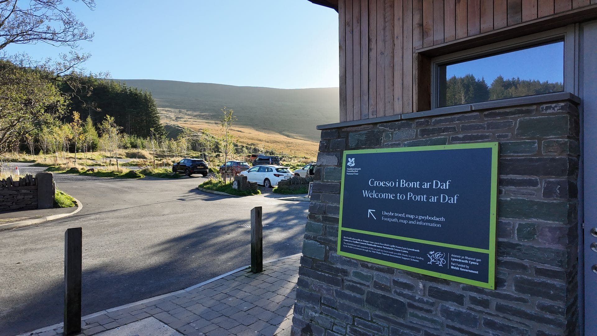
- Best parking: Pont ar Daf (LD3 8NL, ~£7.50/day, National Trust, toilets). Cwm Gwdi (LD3 8NE, pay & display, quieter). Neuadd (free, remote).
- Neighbouring peaks: Corn Du (873m), Cribyn (795m), Fan y Big (719m).
- Dog-friendly: Yes — on lead at all times (livestock grazing).
- Free to climb: Yes — only car parking costs money.
- Pronunciation: “pen uh van” (not “pen ee fan”).
The Four Walking Routes Up Pen y Fan
| Route | Start | Distance | Time | Difficulty | Summits |
|---|---|---|---|---|---|
| The Motorway | Pont ar Daf | 4 mi (6.4km) | 2–2.5 hrs | Easy–Moderate | Pen y Fan + Corn Du |
| Storey Arms Circular | Storey Arms | 4.5 mi (7.2km) | 2.5–3.5 hrs | Moderate | Pen y Fan + Corn Du |
| Cwm Llwch Horseshoe | Cwm Gwdi | 6 mi (9.7km) | 3–4 hrs | Moderate | Pen y Fan + Corn Du |
| Horseshoe Ridge | Neuadd Reservoir | 9.3 mi (15km) | 5–7 hrs | Challenging | Corn Du + Pen y Fan + Cribyn + Fan y Big |
Route 1: The Motorway — Easiest and Most Popular
© Crown copyright Cymru Wales
The regulars call it The Motorway. Starting from Pont ar Daf car park (LD3 8NL, ~£7.50/day, National Trust, toilets), this is the shortest route to the summit. The walk begins at approximately 440 metres, so the total climb is 446 metres of elevation gain over 4 miles.
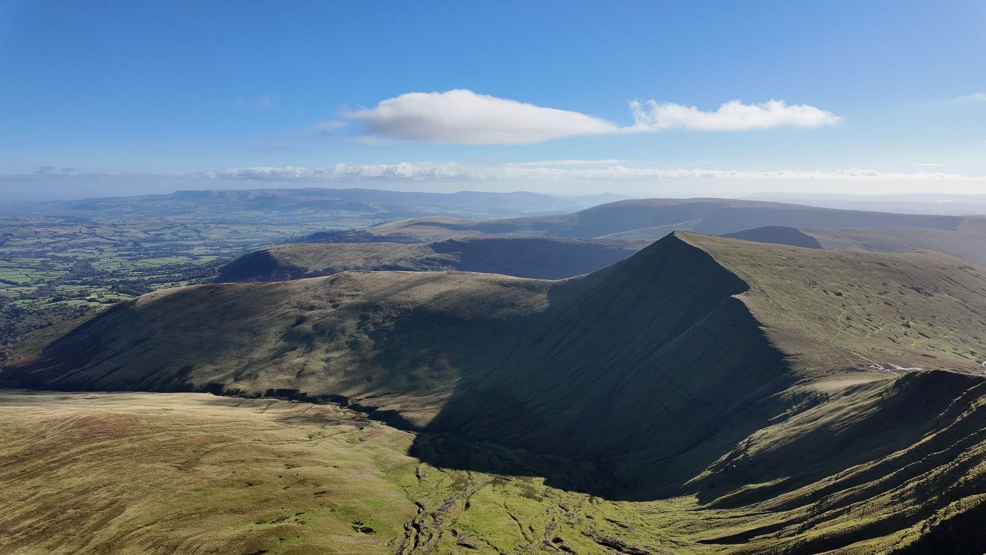
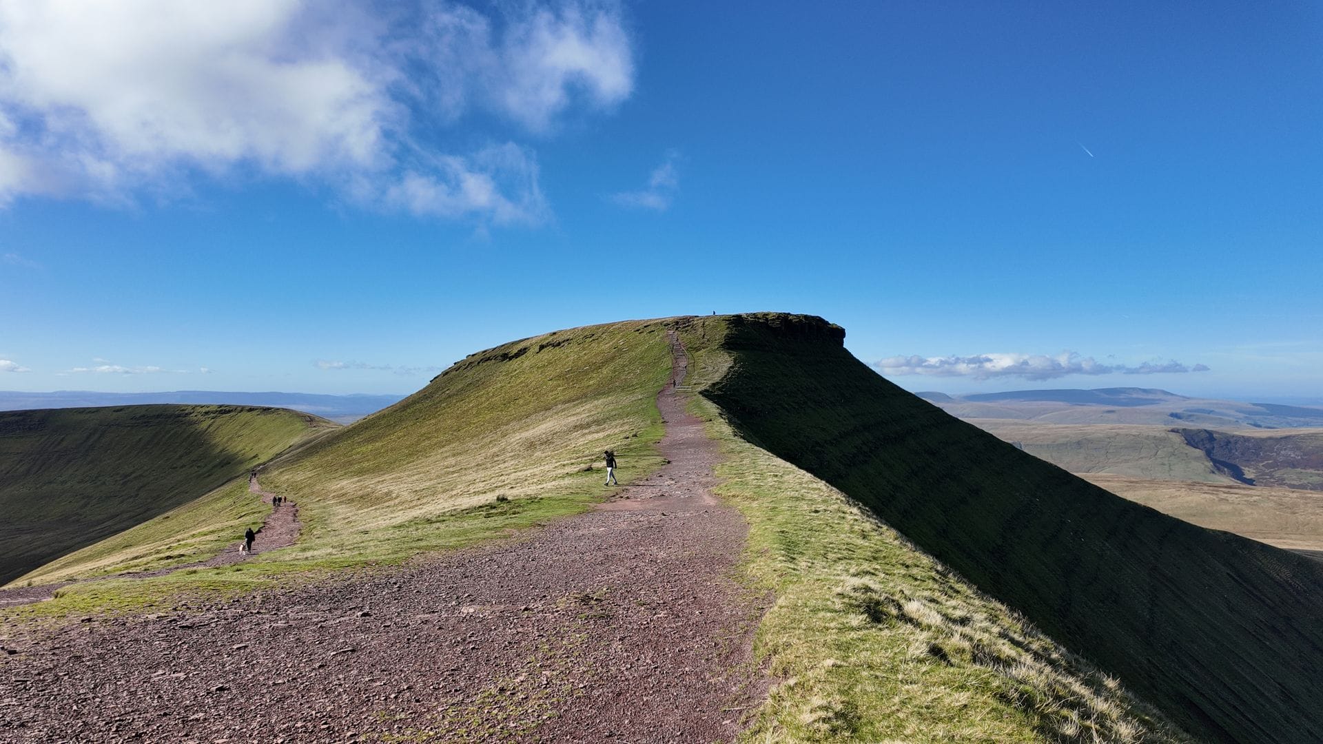
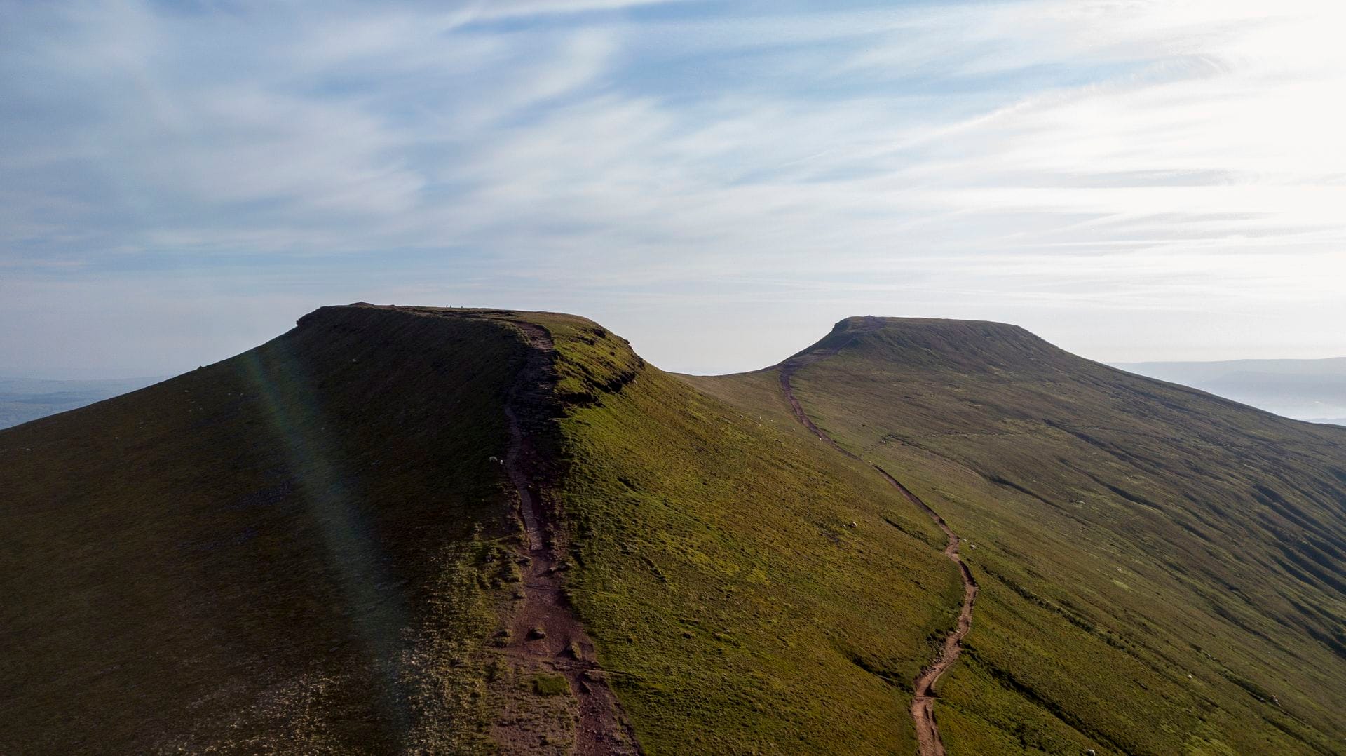
From the car park, pass through the kissing gate, cross the wooden footbridge, and follow the stone footpath uphill. The surface was built to withstand hundreds of thousands of boots per year and holds up well in all conditions. The first 40 minutes are the steepest — a continuous climb across open moorland. As the gradient eases, you reach the saddle between Corn Du (873m) and Pen y Fan. What looks like the summit ahead is actually Corn Du — Pen y Fan is the peak behind it.
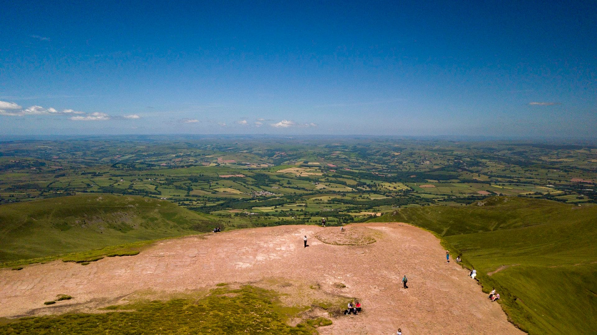
Turn right at the saddle and follow the path to the summit. A short, steep final section with stone steps brings you onto the flat sandstone plateau. The views are extraordinary: Cadair Idris to the north, the Bristol Channel to the south, the Black Mountains to the east, and on clear days, the Preseli Hills 60 miles to the west.
Return the same way, or add Corn Du on the way back — a 15-minute diversion. The cairn on the Corn Du summit is a Bronze Age burial chamber (more on that below).
Best for: First-time visitors, families with children (ages 5+ regularly complete it), anyone wanting the quickest route to the top.
Route 2: Storey Arms Circular — A More Varied Loop
A slightly longer circular route that starts and finishes at Pont ar Daf but loops via the Storey Arms Outdoor Education Centre. The outward leg climbs through woodland, crosses the Blaen Taf Fawr stream on stepping stones, then ascends to the Craig Cwm Llwch ridge before reaching Corn Du and Pen y Fan. The return follows the Motorway path back to the car park.
At 4.5 miles, this adds little distance but provides woodland, a stream crossing, and ridge walking instead of a single stone path. A natural step up from the Motorway.
Best for: Walkers who want a circular route without a major increase in difficulty.
© Crown copyright Cymru Wales
Route 3: Cwm Llwch Horseshoe — Best Views, Fewer People
This is the best route up Pen y Fan. Starting from Cwm Gwdi car park (LD3 8NE, pay and display, no toilets), the walk approaches from the north — revealing the mountain’s most dramatic face. The north-facing cliffs, carved by glaciers during the last Ice Age, drop away steeply below the summit. From this angle, the mountain looks like a frozen wave of stone.
The Cefn Cwm Llwch ridge provides a spectacular elevated walkway with views on both sides. On calm days the walking is straightforward; in cloud, navigation requires more care. The ridge leads directly to the summit, with a steep final scramble.
After summiting, descend via Corn Du and drop to Llyn Cwm Llwch — a glacial lake in the cwm below the north face. Local legend holds the lake is bottomless and conceals a doorway to the Tylwyth Teg (fairy folk). It is in fact one of the highest natural lakes in South Wales and supports rare aquatic plants.
Walk anti-clockwise (ridge up, lake down) for the best experience. The drive to Cwm Gwdi involves narrow single-track lanes from Brecon — the car park is a rough field that fills quickly on weekends, but the walk is worth the effort.
Best for: Experienced walkers seeking the finest views. The best route for photography and sunset walks.
© Crown copyright Cymru Wales
Route 4: The Horseshoe Ridge — Four Peaks in One Day
The Horseshoe Ridge is the definitive Pen y Fan walk — a 9.3-mile circuit summiting all four Central Beacons peaks: Corn Du (873m), Pen y Fan (886m), Cribyn (795m), and Fan y Big (719m). This is a serious day out.
Start from the free Neuadd Reservoir car park (grid ref SO038169, accessed via B-roads from Merthyr Tydfil — narrow, uneven road). Walk past the drained reservoir and climb steeply onto the Craig y Fan Ddu ridge. Follow the ridge north to Corn Du and Pen y Fan — the first two summits.
From Pen y Fan, descend the steep eastern face — Jacob’s Ladder, a punishing set of stone steps dropping 150 metres to the col below Cribyn. This is the same path used in the SAS Fan Dance. The climb to Cribyn from the col is the hardest section of the entire horseshoe — long, steep, and unrelenting.
From Cribyn, a smaller dip and ascent reaches Fan y Big, the fourth peak. Follow the summit ridge south and descend along the eastern valley back to the car park. Allow 5–7 hours.
Best for: Experienced walkers who want a full day in the mountains. Walk clockwise (Corn Du first) to tackle the highest peaks while fresh.
Parking and Getting There
| Car Park | Postcode / Grid Ref | Cost | Toilets | Best For |
|---|---|---|---|---|
| Pont ar Daf | LD3 8NL | ~£7.50/day (NT) | Yes | Motorway & Storey Arms routes |
| Cwm Gwdi | LD3 8NE | Pay & display | No | Cwm Llwch Horseshoe |
| Neuadd Reservoir | SO038169 | Free | No | Horseshoe Ridge |
All car parks fill early on weekends and bank holidays. Arrive before 9am in summer. National Trust members park free at Pont ar Daf. Do not park on grass verges along the A470 — this causes damage and local police issue fines.
By public transport: Train to Merthyr Tydfil (from Cardiff) or bus to Brecon, then the T4 bus to Storey Arms on the A470. This is one of the few major mountain walks in Britain accessible by public transport.
By car: The A470 passes directly alongside Pen y Fan. From Cardiff approximately 1 hour, Swansea 1 hour 15 minutes, Bristol 1 hour 30 minutes, London 3.5 hours via the M4.
What to Wear and Mountain Safety
Mountain Safety: Read Before You Walk
Pen y Fan is a real mountain. Weather can change within minutes — clear skies at the car park can become zero visibility, driving rain, and near-freezing temperatures at the summit. Temperature drops roughly 1°C for every 100 metres of altitude, so the summit is typically 4–5°C colder than the car park before you factor in wind chill across the exposed plateau. Every year, the volunteer-run Brecon Beacons Mountain Rescue Team responds to dozens of incidents on Pen y Fan, most caused by poor preparation.
- Check the weather: Met Office mountain forecast and MWIS (Mountain Weather Information Service).
- Tell someone your route and expected return time.
- Carry a map and compass — mobile signal is unreliable on the mountain.
- The north face summit drop is precipitous. Keep children and dogs close.
- In winter, crampons and an ice axe may be necessary. Only for experienced winter walkers.
- Be prepared to turn back if conditions deteriorate.
Essential: Walking boots (not trainers — the ground is rocky and often wet), waterproof jacket (always, even in summer), warm layers, water (at least 1 litre — no water sources on the mountain), snacks, map, fully charged phone.
Useful: Walking poles (helpful on descents, especially Jacob’s Ladder), sun protection, hat and gloves (year-round — wind chill at 886 metres is significant), head torch for sunrise walks.
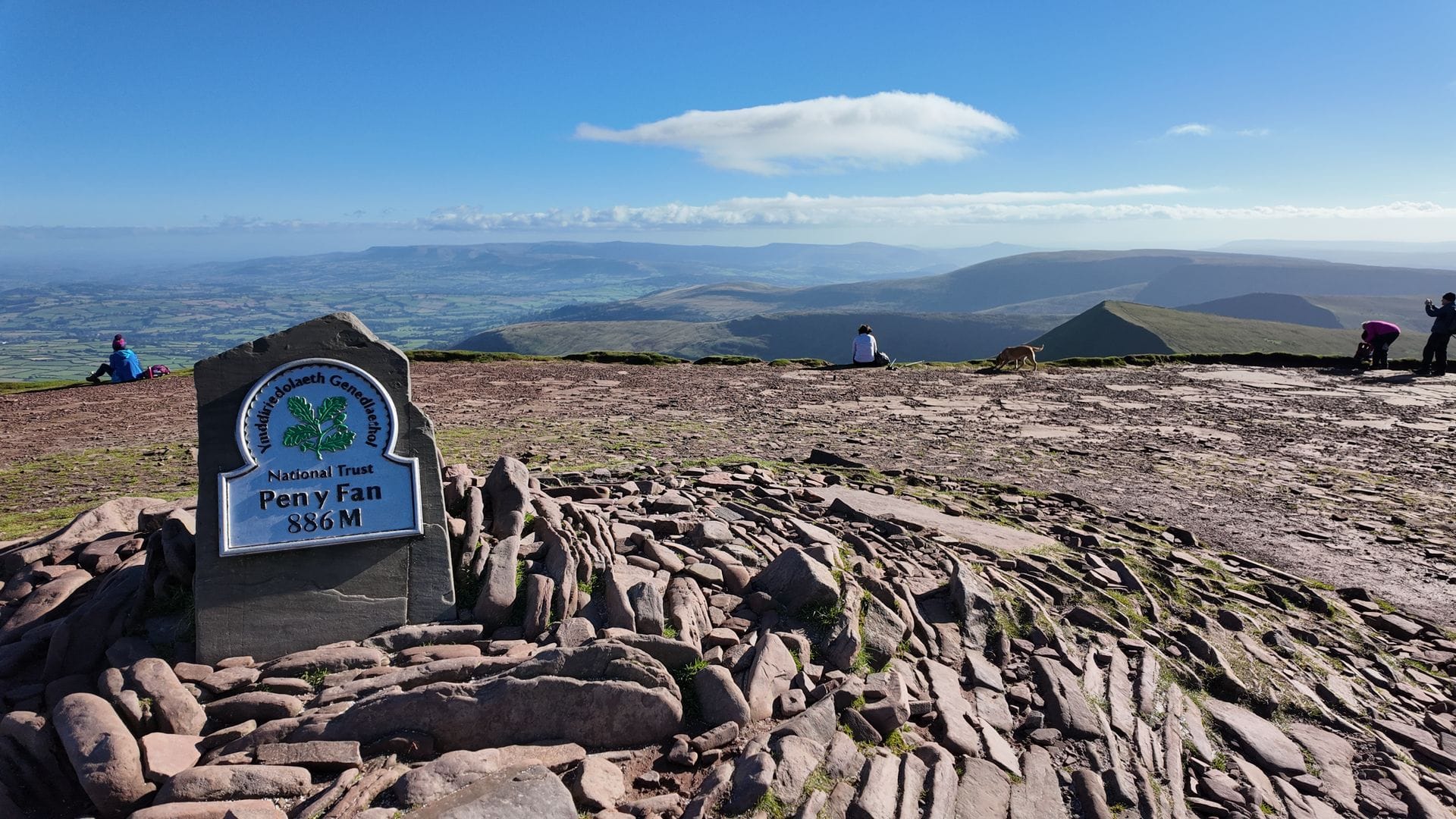
The view when reaching the 886-metre summit marker. © Crown copyright Cymru Wales
The SAS Fan Dance: Military Heritage
Pen y Fan has a military significance no other British mountain shares. The Fan Dance is the gateway test in British Special Forces selection — a 24km (15-mile) timed march carrying 25kg of equipment. Candidates ascend via Jacob’s Ladder (the steep eastern face), descend the far side, follow the old Roman road, then return the same way — all within 4 hours 10 minutes, regardless of weather.
The march has been part of SAS selection since the 1950s. Every SAS soldier since the Regiment moved to the Brecon Beacons has been tested on this mountain. The route is unforgiving — between 1984 and 2019, twenty armed forces personnel died during training exercises in the Brecon Beacons.
Civilian versions are now organised by Avalanche Endurance Events in both summer and winter, open to the public. Even if you never attempt the Fan Dance, you will walk part of the route on any southern ascent. Jacob’s Ladder is unmistakable — a relentless stone staircase dropping 150 metres in a few hundred metres of path.
History and Geology
The flat-topped shape of Pen y Fan is the product of geology and ice. The mountain is formed from layers of Old Red Sandstone, laid down approximately 400 million years ago beneath a shallow tropical sea. The harder sandstone cap resists erosion, creating the flat summit plateaux. Softer layers beneath have been carved away by glaciers over successive Ice Ages. The dramatic north-facing cwm walls formed during the last glaciation, approximately 10,000 years ago.
The name Pen y Fan translates from Welsh as “top of the peak” or “head of the high place.” It is pronounced “pen uh van” — not “pen ee fan.”
Tommy Jones Obelisk
Near the summit of Corn Du stands a small stone obelisk — a memorial to Tommy Jones, a five-year-old boy who died on the mountain in August 1900. Tommy was walking with his father from Cwm Llwch to the Login farm when he became separated in darkness. His body was found 29 days later near the Corn Du summit, 400 metres above the spot where he was last seen. The memorial, erected in 1901, is one of the most sobering landmarks in the Welsh mountains.
Bronze Age Burial Cairn
The summit cairn on Corn Du is a Bronze Age burial chamber, approximately 4,000 years old. When excavated in 1991, archaeologists found a bronze brooch and spearhead inside, dating the burial to roughly 2000 BC. This mountain was sacred to people who lived in the valleys below thousands of years before the Romans, the Normans, or the SAS arrived.
Pen y Fan vs Yr Wyddfa (Snowdon)
Yr Wyddfa (Snowdon) is the highest peak in Wales at 1,085m — 199 metres taller than Pen y Fan. However, the Motorway route starts at 440m, meaning the actual vertical climb (446m) is comparable to several of Yr Wyddfa’s easier paths. Both mountains share unpredictable weather that demands proper preparation regardless of the forecast at the car park.
When to Visit
Spring (March–May): Longer days, wildflowers on the lower slopes. Snow possible into April. Quieter than summer.
Summer (June–August): Busiest season. Longest daylight. Best chance of clear summit views. Arrive before 9am for parking. Weekdays significantly quieter.
Autumn (September–November): Often the best season. Autumn colour in the valleys, fewer visitors, crisp days, and the chance of cloud inversions at sunrise — the summit sitting above a sea of cloud filling the valleys below.
Winter (December–February): Spectacular when snow-covered but genuinely challenging. Short daylight, icy paths, potential blizzards. Crampons and ice axe may be essential. Experienced winter walkers only.
Sunrise walks: Pen y Fan is one of the best sunrise viewpoints in Wales. The summit faces east, catching the first light as it breaks over the Black Mountains. Arrive at Pont ar Daf approximately 90 minutes before sunrise and walk up with a head torch. Check sunrise times and weather carefully.
You’ve got the walk. Now plan the week around it.
Eight questions, two minutes — and we’ll build you a personalised Bannau Brycheiniog itinerary with three hand-picked cottages, three experiences, and food recommendations from people who actually live there.
Plan The Whole WeekWhere to Stay Near Pen y Fan
Whether you are looking for a lively local pub, a budget-friendly bunkhouse for a group hike, or a luxury cottage to rest your legs, use the interactive map below to find the best accommodation closest to the trails.
Where to Eat and Stay
The town of Brecon (15 minutes from Cwm Gwdi) has the best selection of pubs and restaurants near the mountain. The Felin Fach Griffin is listed in the Good Food Guide’s 100 best pubs. The Star Inn at Talybont-on-Usk and The Tai’r Bull in Libanus both welcome muddy boots. A burger van is usually parked at Storey Arms for immediate post-hike sustenance.
For accommodation, browse holiday cottages in the Brecon Beacons, campsites, glamping, and hotels near Brecon. For more walking, try the Four Waterfalls Walk at Ystradfellte (30 minutes’ drive) or explore our hiking in Wales guide.
© Crown copyright Cymru Wales
On the Mountain: Etiquette and Leave No Trace
Pen y Fan’s popularity means looking after it is everyone’s responsibility. The National Trust marker at the summit is iconic — on busy summer weekends, expect a queue to photograph it. Take your shots quickly and offer to take a picture for the group behind you. The Brecon Beacons Mountain Rescue Team is entirely volunteer-run and responds to dozens of incidents on Pen y Fan every year, most related to poor weather preparation. Carry your litter home — including biodegradable items like banana peels, which take years to decompose at altitude.
Frequently Asked Questions
How high is Pen y Fan?
886 metres (2,907 feet) — the highest mountain in southern Britain. The summit is a flat plateau of Old Red Sandstone with dramatic glacial cliffs on the north face. Corn Du, connected by a short saddle, reaches 873m.
How long does it take to walk up?
Motorway (Pont ar Daf): 2–2.5 hours, 4 miles. Storey Arms circular: 2.5–3.5 hours, 4.5 miles. Cwm Llwch Horseshoe (Cwm Gwdi): 3–4 hours, 6 miles. Horseshoe Ridge (Neuadd): 5–7 hours, 9.3 miles, four summits.
Where do I park?
Pont ar Daf (LD3 8NL, ~£7.50, NT, toilets — most popular). Cwm Gwdi (LD3 8NE, pay & display, quieter). Neuadd (SO038169, free, remote). Arrive before 9am on weekends. NT members park free at Pont ar Daf.
Is Pen y Fan difficult?
The Motorway route suits families with active children — no scrambling, well-maintained path. The Horseshoe Ridge is a serious walk. Weather is the main variable. Check the Met Office mountain forecast before setting out.
What is the SAS Fan Dance?
A 24km timed march carrying 25kg, ascending via Jacob’s Ladder. SAS selection since the 1950s. 4 hours 10 minutes to complete. Civilian versions run by Avalanche Endurance Events.
Can I take my dog?
Yes — on lead at all times (livestock grazing year-round). Bring water. Keep dogs away from cliff edges. Take waste home.
Pembrokeshire-born travel writer and founder of Wales.org. Born in Haverfordwest, now based in Hertfordshire — covering Welsh castles, national parks, festivals and family staycations across all 22 Welsh counties.